
Gavin Grimmer


I wonder if they just cleared that section or unearthed a line of concrete i.e. Did the concrete go out as far as this all the way around the perimeter or was it just like a concrete pathway going in this direction?
It was believed this map was possibly dated around 1946, but it is now obvious that is more likely in the era of the 1960’s, especially as it shows the existence of the perimeter road.
Note that the road was made going over the edge of the Burster Slab and you’ll note
on the photo on the previous page that the tyre tracks go right up to the edge of
this slab. 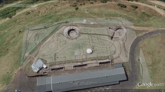
It’s rather interesting that at some stage this Burster Slab has been broken by presumably
a heavy vehicle driving over the edge presumably while using this road.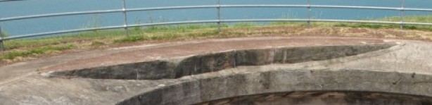 You’ll notice
that this loading on the outer edge of the slab has caused the concrete to rise up
above the surrounding concrete. This can only happen if there is a pivoting fulcrum
which may be another outside wall, and may be not? Whichever, it is obvious the outer
section of the slab has been pushed down
You’ll notice
that this loading on the outer edge of the slab has caused the concrete to rise up
above the surrounding concrete. This can only happen if there is a pivoting fulcrum
which may be another outside wall, and may be not? Whichever, it is obvious the outer
section of the slab has been pushed down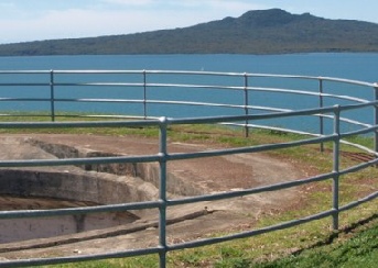 as the Parks Board has filled that area
with cement to bring it back up to the original level. The mere fact that it has
collapsed down does tend to point that the ground out in that area is either rather
unstable or there was a hollow such as a tunnel.
as the Parks Board has filled that area
with cement to bring it back up to the original level. The mere fact that it has
collapsed down does tend to point that the ground out in that area is either rather
unstable or there was a hollow such as a tunnel.
In Mitchell’s Report, he shows these photos: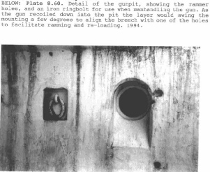
Although these photos are of the Disappearing Gun in the Southern Battery, this is
the same gun as it was moved down to this position in 1953 and the pit was built
almost identical to the summit main gun pit. These ramming holes give the extra space
for the ramming pole to be used in the breech without making the pit any larger target
than it needs to be. I was initially suspicious of there being an underground surrounding
outer room 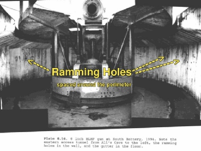 around the perimeter of the gun pit to enable ramming of the ammunition
from outside the wall through these holes, but it appears these blind holes were
only there to put the long shafts of the ramming rods in. This doesn’t mean that
there were not any external tunnels though, as if this tunnel shown on the Maritime
map is correct, then the only way you could get to it is via another tunnel outside
of these gun pit walls as there is no sign of the existing walls as having been disturbed.
You can see pretty much right around the inside of this summit gun pit wall in various
photos taken over the years, and the only entrances that you can see is the one at
the rear and the two going off either side - one to the north and one to the south
as per the illustration above overlaid on Google Earth
around the perimeter of the gun pit to enable ramming of the ammunition
from outside the wall through these holes, but it appears these blind holes were
only there to put the long shafts of the ramming rods in. This doesn’t mean that
there were not any external tunnels though, as if this tunnel shown on the Maritime
map is correct, then the only way you could get to it is via another tunnel outside
of these gun pit walls as there is no sign of the existing walls as having been disturbed.
You can see pretty much right around the inside of this summit gun pit wall in various
photos taken over the years, and the only entrances that you can see is the one at
the rear and the two going off either side - one to the north and one to the south
as per the illustration above overlaid on Google Earth
NH Page 43